
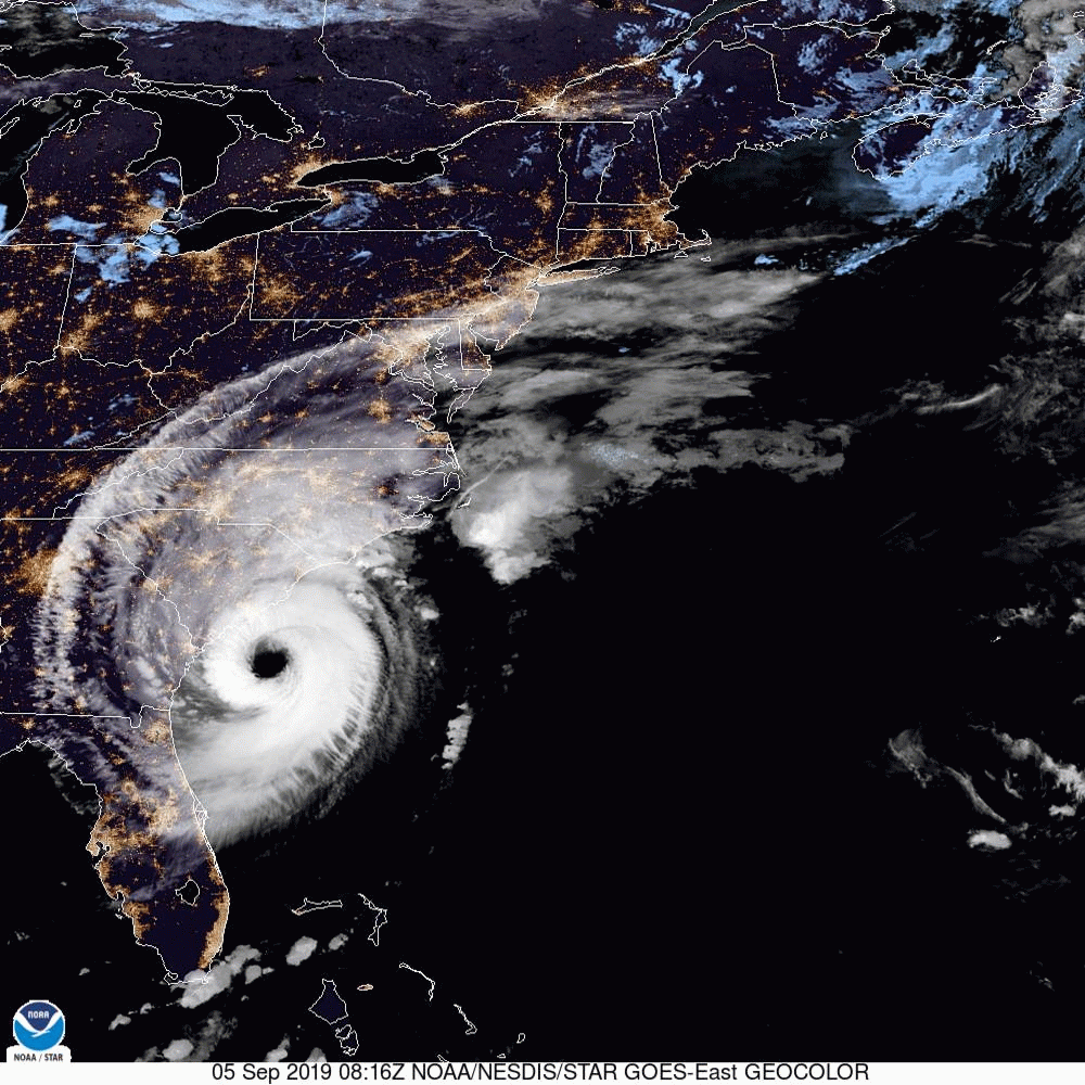
UPDATE 9/5/2019 8:00am:
At 800 AM EDT (1200 UTC), the eye of Hurricane Dorian was located directly off the coast of Charleston, moving toward the north-northeast near 8 mph (13 km/h). A turn toward the northeast and a faster forward speed is forecast tonight and tomorrow n Friday. The center of Dorian will continue to move close to the coast of South Carolina today, and then move over the coast of North Carolina tonight and Friday.
Maximum sustained winds are near 115 mph (185 km/h) with higher gusts. Dorian is a category 3 hurricane. Some fluctuations in intensity are expected this morning, followed by slow weakening. Dorian is expected to remain a hurricane through the weekend.
Hurricane-force winds extend outward up to 60 miles (95 km) from the center, and tropical-storm-force winds extend outward up to 195 miles (315 km).
UPDATE 9/3/2019 11:00am:
This morning at 11am, the National Hurricane Center released the following update:
“At 1100 AM EDT (1500 UTC), the eye of Hurricane Dorian was located near latitude 27.1 North, longitude 78.6 West. Dorian is moving toward the northwest near 2 mph (4 km/h), and a slightly faster motion toward the northwest or north-northwest is expected later today and tonight. A turn toward the north is forecast by Wednesday evening, followed by a turn toward the north-northeast Thursday morning. On this track, the core of extremely dangerous Hurricane Dorian will gradually move north of Grand Bahama Island through this evening. The hurricane will then move dangerously close to the Florida east coast late today through Wednesday evening, very near the Georgia and South Carolina coasts Wednesday night and Thursday, and near or over the North Carolina coast late Thursday and Thursday night.”
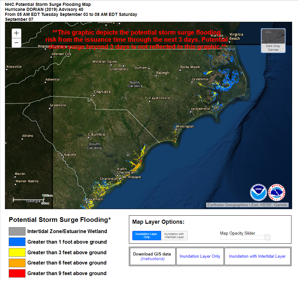
Due to the Westward shifted forecast, “THE STORM SURGE WATCH HAS BEEN EXTENDED NORTHWARD TO CAPE LOOKOUT NORTH CAROLINA.”
According to Ventusky.com, the eye-wall of the storm is shown making initial landfall near Wilmington, NC at around 5pm on Thursday evening;
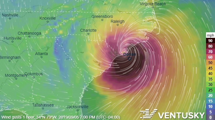
Several areas around Myrtle Beach and Wilmington are are now expected to see storm surges in excess of 9 feet within the next 3 days;
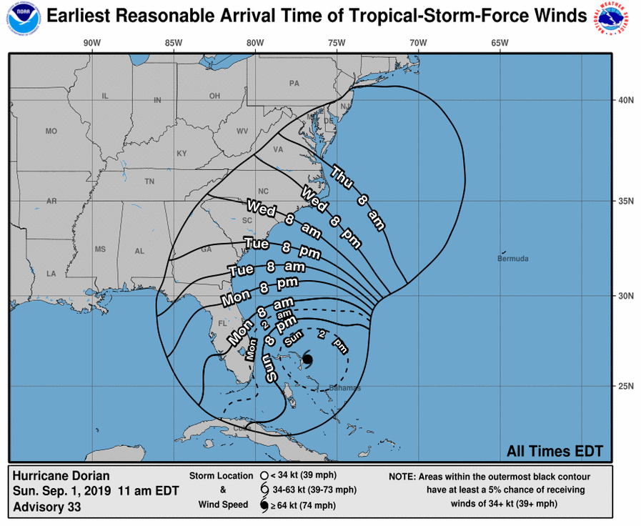
UPDATE 9/1/2019 2:00pm:
The historic Category 5 Hurricane Dorian just made landfall in the Bahamas with 185 mph sustained winds and gusts over 220 mph in Elbow Cay, Abacos.
“This is tied for the strongest Atlantic hurricane landfall on record with the 1935 Labor Day hurricane,” according to the National Hurricane Center. The storm is now producing 18 to 23 feet storm surges with even higher waves.
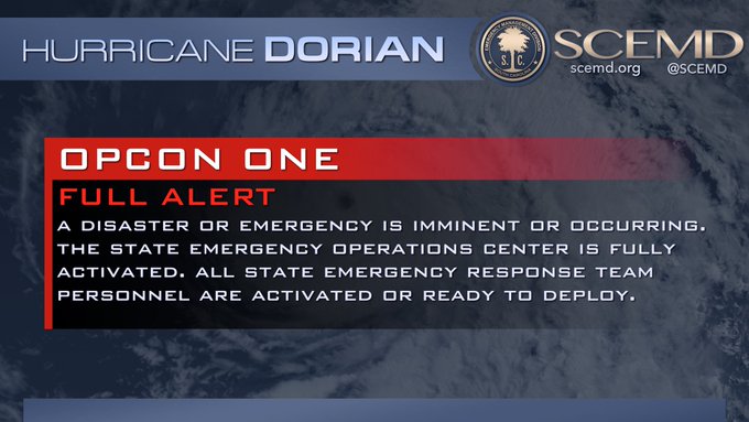
The State of South Carolina has just declared the highest possible State of Emergency ahead of Category 5 Hurricane Dorian.
According to this morning’s alert, the state is now at ‘OPCON 1 – Full Alert’, “All state emergency response team agencies are activated to prepare for any potential effects from Hurricane #Dorian.”;
The South Carolina Emergency Operations Center is now at Operational Condition One: Full Alert. All state emergency response team agencies are activated to prepare for any potential effects from Hurricane #Dorian. #sctweets #scwx pic.twitter.com/D9O07Is0KX
— SCEMD (@SCEMD) September 1, 2019
In a press release, SCEMD Director Kim Stenson said, “It is vital that every resident have a personal emergency plan and be ready to take action if told to do so.”
All residents of South Carolina should download the SC Emergency Manager mobile app to build a personal emergency plan, keep track of emergency supplies, and have a way to stay connected with loved ones in addition to official emergency information. The SC Emergency Manager is available in the App Store and on Google Play: http://onelink.to/dn92rx
The official 2019 S.C. Hurricane Guide is available at scemd.org.
The guide recommends having the following emergency items stocked in your home (available via 2-day shipping on Amazon.com if your local store has already been cleaned out);
- Car charger for cell phones and other devices
- Clean drinking water (recommended 1 gallon per person per day, minimum three days)
- Flashlights
- Batteries: Extra batteries for all of your devices
- Weather radio/clock
- Non-perishable food
- First aid kit
The National Hurricane Center has issued the following public advisory:
Maximum sustained winds have increased to near 180 mph (285 km/h)
with higher gusts.  Dorian is a extremely dangerous category 5
hurricane on the Saffir-Simpson Hurricane Wind Scale.  Some
fluctuations in intensity are likely, but Dorian is expected to
remain a powerful hurricane during the next few days.
Damaging winds are now expected to reach South Carolina by Tuesday afternoon;
We will continue to update this article as Tropical Storm Dorian develops.
