
 What could become the Carolina’s largest winter storm of the year is now taking shape for this weekend and the NWS is asking people to prepare.
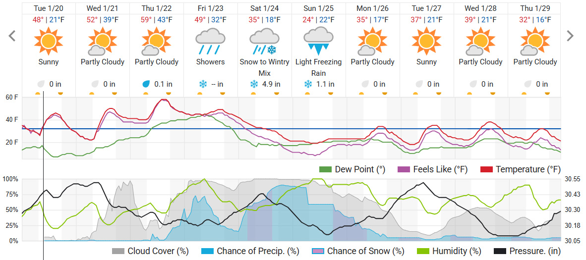
Forecasts point to snow developing early Saturday, then mixing with freezing rain after sunrise. The best window for snow in the Queen City appears to be the pre-dawn hours, when colder air is in place and temperatures dip to around 28 degrees.
By daybreak, temperatures could rise just above freezing, which is when the storm’s bigger threat begins.
Increasing confidence that a Winter Storm will impact the western Carolinas and northeast Georgia over the weekend.#scwx #ncwx #gawx https://t.co/uhUyCyB4N6
— NWS GSP (@NWSGSP) January 20, 2026
After sunrise Saturday, snow may change to a messy mix that includes freezing rain and sleet. Highs are expected to hover in the low-to-mid 30s, which keeps much of the area near the freezing line. That makes it easier for small temperature changes to flip conditions from “wet” to “dangerous” within minutes.
Saturday night could bring the worst impacts. Lows near 19 degrees would freeze anything left on roads, sidewalks, and parking lots. If precipitation continues into the evening, ice could build on trees, power lines, and untreated surfaces. Even if snowfall totals stay modest, freezing rain can create more disruption than snow in a hurry.
The wintry mix could linger into Sunday morning, and cold air looks locked in. Sunday’s low could drop near 13 degrees, which means refreezing becomes a major concern. Any slush or standing water can turn into black ice, even after precipitation tapers off. Lingering slick spots could extend into Monday, especially on bridges, overpasses, and shaded roads.
This storm is unlikely to be a clean, all-snow event. The atmosphere can layer warm air above cold air, causing snowflakes to melt into rain before refreezing at the surface.
Ice is the bigger concern for most neighborhoods. A quarter-inch of ice can be enough to weigh down branches and strain power lines, increasing the risk of widespread power outages. It also creates the most hazardous driving conditions, because roads can look merely wet while turning into an ice sheet.
Now is the time to prepare, even if the final details shift.
North Carolina Emergency Management officials remind all residents to:
- Keep enough water in your home for 3 days.
- Keep enough non-perishable food in your home for 3 days.
- Keep fresh batteries on hand for weather radios and flashlights.
- Dress warmly. Wear multiple layers of thin clothing instead of a single layer of thick clothing.
- Properly vent kerosene heaters and keep any electric generators outside and away from open windows or doors to prevent carbon monoxide poisoning. Never burn charcoal or operate grills indoors.
- Monitor changing forecasts and weather conditions closely.
- Keep an vehicle emergency kit, blankets, and sand/salt in your car.
- Top off all your vehicle’s fluids, especially your oil, power steering fluid, and antifreeze.

