
Update 1/10/2025 11:00am:
Charlotte can now expect over 1.5 inches of snow, with 2+ inches possible in the northwestern parts of our city.
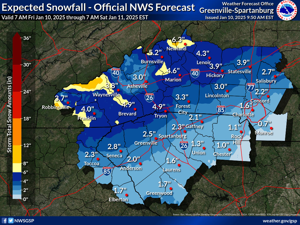
The National Weather Service just issued the following alert for our region:
...WINTER STORM WARNING REMAINS IN EFFECT UNTIL 7 AM EST SATURDAY...

* WHAT...Heavy mixed precipitation expected. Total snow and sleet
  accumulations up to two inches and ice accumulations between one
  tenth and one quarter of an inch.

* WHERE...Portions of northeast Georgia, Piedmont North Carolina,
  and Upstate South Carolina.

* WHEN...Until 7 AM EST Saturday.

* IMPACTS...Snow and ice accumulations will make many roads
  treacherous and impassable. The weight of the snow and ice on tree
  limbs and power lines could produce isolated outages. The
  hazardous conditions could impact the Friday morning and evening
  commutes.

PRECAUTIONARY/PREPAREDNESS ACTIONS...

Monitor the latest forecasts for updates on this situation.

Slow down and use caution while traveling.

If you must travel, keep an extra flashlight, food, and water in
your vehicle in case of an emergency.
Original Article 1/2/2025 11:00am:
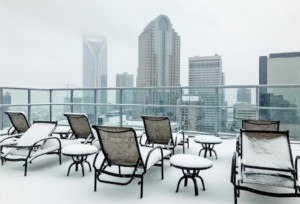 Charlotte is bracing what could become its first significant ‘snowstorm’ of the season as temperatures continue to drop throughout the week.
Forecasters predict sunny but frigid weather through Thursday, with daytime highs in the 40s and overnight lows plunging into the teens and 20s.
A developing storm system moving from the Gulf of Mexico is expected to bring snow to the region starting Friday afternoon. Areas north and west of Charlotte may see higher snow accumulations, while those south and east of I-85 could experience more ice.
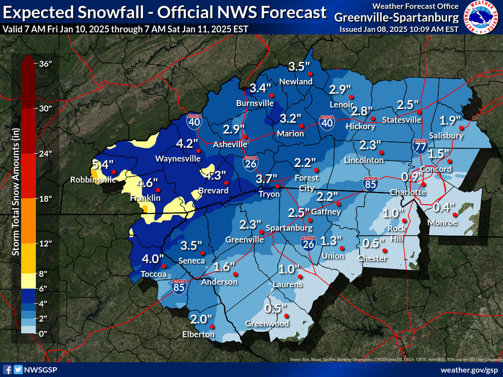
The National Weather Service (NWS) is forecasting around an inch of snow for many parts of Charlotte and potentially over a foot of snow in some parts of the NC mountains:
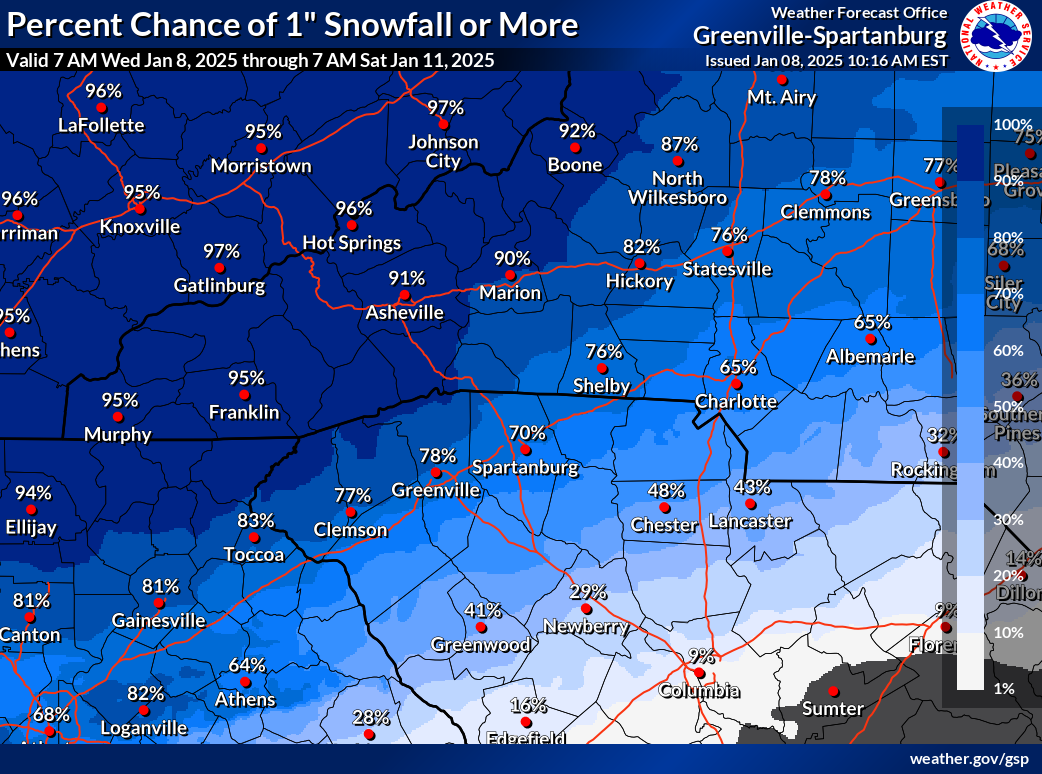
The NWS is currently giving Charlotte a 65% chance of seeing 1″ or more of snow by Saturday.
The storm is projected to clear by Saturday morning, ushering in sunny but cold conditions over the weekend. Hazardous road conditions are likely Friday evening, so drivers should prepare for potential delays and icy spots.
If you moved here from Ohio or New York, you may be rolling your eyes, but if you’re from Florida or California, you might need to make some changes to prepare for the coming winter storm.
To prepare your car, top off all your fluids, especially your oil, power steering fluid, and antifreeze. You’ll also want to check your tires and make sure your air pressure is over 32 PSI.
To prepare your home, make sure to drain all fountains and exterior water fixtures. Always let at least one of your faucets drip to avoid freezing pipes. Consider buying a humidifier if you’re sensitive to dry air. If you have an older home with older windows, investing in some shrink film insulation will save you a ton on your heating bill.
To prepare yourself, buy some thermal gloves, a warm hat, and a winter jacket. If you’re going to spend any length of time outside, you may even want to consider buying an electric heating jacket.
If you have a pet – make sure to read our article about how to keep your furry friend warm!

