
Rain will develop across the region today and become heavy at times. Embedded thunderstorms may be strong, with isolated severe storms possible mostly along/southeast of I-85 from 2 pm to 10 pm. Expect gusty winds to develop, with a Wind Advisory in place for much of the area. pic.twitter.com/uHsaEj2tLj
— NWS GSP (@NWSGSP) January 12, 2024
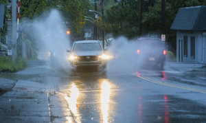 As the Carolinas recover from Tuesday’s storm featuring record rainfall and a tornado in Catawba County, another storm is forecasted for Friday afternoon. This system will bring gusty winds, heavy rain, and possible severe storms, mainly affecting the afternoon and early evening.
Though not as severe as Tuesday’s event, Friday’s storm could still cause a ton of issues, with wind gusts expected between 30 to 40+ mph, potentially toppling shallow-rooted trees due to saturated soil, and chances of flash flooding across our region.
Some areas around Charlotte could see up to 1 to 2 inches in heavier downpours.
North Carolina Emergency Management officials remind all residents to:
- Keep enough water in your home for 3 days.
- Keep enough non-perishable food in your home for 3 days.
- Keep fresh batteries on hand for weather radios and flashlights.
- Dress warmly. Wear multiple layers of thin clothing instead of a single layer of thick clothing.
- Properly vent kerosene heaters and keep any electric generators outside and away from open windows or doors to prevent carbon monoxide poisoning. Never burn charcoal or operate grills indoors.
- Monitor changing forecasts and weather conditions closely.
- Keep an vehicle emergency kit, blankets, and sand/salt in your car.
- Top off all your vehicle’s fluids, especially your oil, power steering fluid, and antifreeze.

