
 Forecasters are tracking a slow-moving weather pattern that could develop into a tropical storm or hurricane.
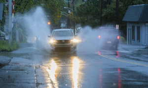
A stalled frontal boundary is expected to weaken near the southeastern coastline, including parts of Florida and the Carolinas. That stalled front could lead to the development of a low-pressure area by the weekend. If this occurs, slow and gradual tropical or subtropical development could follow.
Currently, NHS models are hinting at potential storm formation near the Fourth of July holiday. But forecasters emphasize that multiple limiting factors are in place. Dry air, wind shear, and land interaction could prevent any system from strengthening significantly.
Those traveling or vacationing along the Gulf Coast, Florida, or the Carolinas should monitor updates closely. The situation could change quickly if conditions become more favorable.
If a tropical system does develop, the next name on the Atlantic hurricane list is Chantal.
During this hurricane season, North Carolina is introducing Know Your Zone, a tiered evacuation system that highlights areas most vulnerable to storm surge from hurricanes and tropical storms, and other hazards. If it becomes necessary, local officials will order evacuations using pre-determined zones created by coastal counties. The Know Your Zone lookup tool is a new color-coded interactive map you can use to determine the evacuation zone where you live, work, or are visiting based upon street address.
Oofficials are also recommending that all Carolina residents prepare for possible power outages from hurricane damage. The following emergency items are suggested;
- Car charger for cell phones and other devices
- Clean drinking water (recommended 1 gallon per person per day, minimum three days)
- Flashlights
- Batteries: Extra batteries for all of your devices
- Weather radio/clock
- Non-perishable food
- First aid kit

