
The Charlotte region saw its first snow and freeze of the season as Arctic air swept through our area yesterday and today.
Flurries dusted most areas south of I-40 – even down into Rock Hill, Fort Mill, and Indian Land – marking the coldest morning in more than 250 days.
In the mountains, conditions were far harsher and the snow was far thicker — with Boone and surrounding areas feeling like 5 degrees amid biting wind chills.
HEAVY snowfall rates in this snow squall near Linville, NC. Might be the heaviest snow I have ever seen. Unbelievable! pic.twitter.com/wcgqr6bDUr
— Henry Burton (@HenryWX) November 10, 2025
A Freeze Warning remains in effect until 9 am for most of the Charlotte region, including Gaston, York, Cabarrus, Chesterfield, and Union counties. Residents are urged to protect sensitive plants and pipes as temperatures dip into the 20s and 30s.
Today will stay brisk and sunny, with highs struggling to reach 48 degrees and wind gusts topping 20 mph. Overnight lows will settle near 35 degrees, before a sharp warmup midweek.
By Wednesday, highs jump to the mid-60s, and temperatures climb into the upper 60s and low 70s by Friday. The warmth continues through the weekend before another mild front moves in Sunday night, bringing slightly cooler air and a small chance of showers.
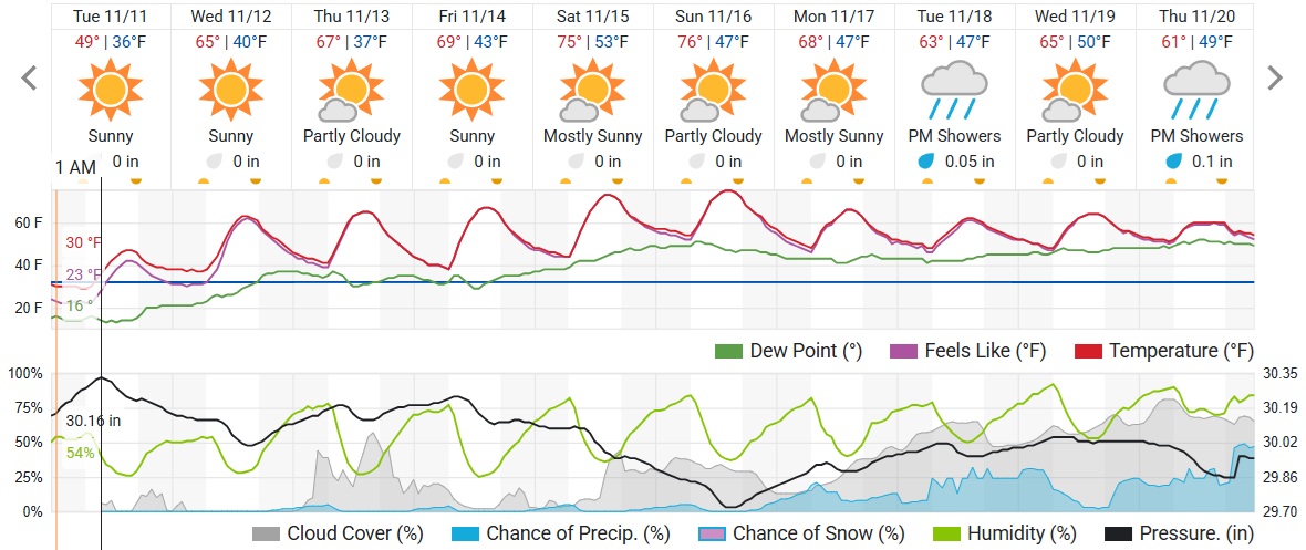
After a brief taste of winter, the Queen City will quickly return to fall — with plenty of sunshine and no significant rain in sight.

