
Update 1/29/26 9:00am:
Forecasts are now showing even greater possible impacts of the developing storm on the Charlotte region – a total of 4-8 inches of snow are now possible for the northern parts of the Charlotte area.
The National Weather Service out of Greenville/Spartanburg just issued the following alert for our region:
Winter Storm Watch issued January 29 at 2:16AM EST until February 1 at 7:00AM EST by
NWS Greenville-Spartanburg SC
* WHAT…Heavy snow possible. Total snow accumulations between 4 and
7 inches east of I-26. Total accumulations between 2 and 4 inches
across the remainder of the area. Wind gusts of 25 to 35 mph.
* WHERE…Northeast Georgia, western North Carolina, and Upstate
South Carolina.
* WHEN…From Friday afternoon through Sunday morning.
* IMPACTS…The heavy snow will make many roads impassable and may
produce scattered power outages due to the weight of the snow on
tree limbs and power lines. The hazardous conditions could impact
the Friday evening commute. Gusty winds could bring down tree
branches.
* ADDITIONAL DETAILS…Snow is expected to rapidly stick to roads
and other surfaces due to temperatures in the 20s. Travel
conditions could deteriorate rapidly as early as Friday evening.
Very gusty winds on Saturday could result in areas of blowing
snow, causing very poor visibility
Original Article 1/27/26 9:30am:
 Another winter storm is now brewing that could bring Charlotte it’s first significant snowfall of the season this coming weekend.
Forecasters expect clouds to increase Friday, then snow chances rise overnight. Snow could continue into Saturday before tapering Saturday night. Saturday’s high is forecast near the upper 20s, with lows near the mid-teens.
The Weather Prediction Center is currently predicting a 40% chance of at least moderate winter storm impacts for the Charlotte region.
According to Weather Underground, Charlotte could see up to 4.9 inches of the white stuff on Friday night and Saturday morning.
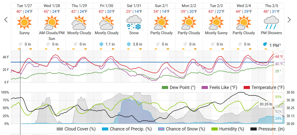
Either way, the lingering cold matters after the flakes fall. It can keep roads slick longer and slow melting into early next week.

