
Update 2/1 8am:
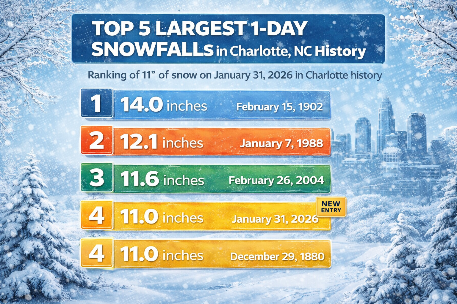
Charlotte just experienced her 4th largest single-day snowfall in recorded history. The Charlotte Douglas Airport officially recorded a total of 11 inches of snowfall, tying a record set all the way back in 1880.
Other parts of the Charlotte region saw even greater totals – here are the latest reported snow totals as of Sunday morning at 8am:
-
Charlotte: 11”
-
Salisbury: 12”
-
Kannapolis: 12.5”
-
Davidson: 9”
-
Pineville 8.3″
-
Belmont: 8”
-
Tega Cay: 7″
Original Article 1/31 8pm:
A historic snow is piling up across the Charlotte region, and early totals show just how rare this snowstorm is for the Queen City. Reports compiled by local forecasters Saturday afternoon show several communities already reached 6 to 12 inches, with snow still falling in most areas across the Charlotte region.
Our city has seen a massive number of accidents as thousands of people ignored the warnings and took to the streets today.
Here are the latest reported snow totals as of Saturday afternoon at 7pm:
-
Charlotte: 7.2”
-
Salisbury: 11”
-
Kannapolis: 11.2”
-
Davidson: 8”
-
Beech Mountain: 9.4”
-
Boiling Springs: 8.6”
-
Belmont: 7”
-
Lawndale: 6.7”
-
China Grove: 11.9”
-
Indian Land: 2.8”
The storm is also locking in dangerous cold. Extreme Cold Warnings cover much of the region through Sunday morning. Wind chills could drop below zero near Charlotte, and far lower in the mountains.
Meanwhile, the system is strengthening rapidly off the East Coast into a bomb cyclone, raising blizzard and coastal flooding risks farther east.
Nationally, the danger is growing as bitter air spreads south. The Associated Press reported more than 100 deaths tied to the recent wave of extreme cold and winter weather across multiple states.
For the Charlotte region, the impact is immediate. Roads will stay hazardous as temperatures fall, and melting will be slow through the cold stretch over the next few days.
